Data selection |
|
There are 7 functions for the purchase by selection in the map window. These functions are located in the group “Selection functions”:
|
Purchase of one export unit |
Adds one export unit in the place of the click |
|
Purchase with line |
Adds all export units crossed with specified line (terminated with a double click) |
|
Purchase with general polygon |
Adds all export units inside the polygon (terminated with a double click) including the units crossed with the polygon |
|
Purchase with rectangle |
Adds all export units inside the rectangle (specified with drag and drop) including the crossed with the rectangle |
|
Purchase by entering the number or name of the export unit |
Adds all export units corresponding to the entered requests (asterisk as a placeholder can be used) |
|
Purchase with coordinates |
Adds all export units inside the rectangle specified by a bounding box (format Ymax;Xmax;Ymin;Xmin with minus sign for S-JTSK datum) |
|
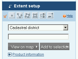
Selection with specification of spatial area |
Adds all export units inside or on the boundary of selected spatial area |
Selected export units are immediately displayed in the dialog “Your selection”. In case of non-digital product, the repeated selection is considered as an increase of number of items.
Selection of one export unit
This function makes possible selection of export units with simple clicking into the export units map layout with overview map background. Moving the cursor over the map displays also a description informing about the name of export unit under the current position.
Selection with line
This function makes possible selection of export units with a polyline. All export units crossed with the line are selected (the function will be terminated with a double click).
Selection with polygon
This function makes possible definition of the area with a general polygon. The polygon will be defined by clicking in location of intended vertexes; definition of the polygon is terminated with a double click (the location of the double click is not considered as a vertex). The polygon must be OGIS specification conformant, i.e. the border line can’t cross itself. The defined polygon is transformed to the list of export units inside or at least crossed with the polygon.
Selection with rectangle
This function makes possible purchase with a rectangle in the map. It will be defined by drag and drop in the map. Defined rectangle is transformed to the list of export units inside or at least crossed with it.
Selection with search
This function displays a dialogue frame for direct entering of export units by the list of their names. The names shall be entered without spaces and hyphens but separated by semicolons. “*” is allowed as a placeholder.
Selection with coordinates
The function displays a dialogue frame for entering of coordinates of pair of points defining the requested area. The coordinates of the crop as YmaxXmax;YminXmin in the S-JTSK datum shall be entered. There is a template in the frame. Entered rectangle is transformed to the list of export units inside or at least crossed with it.
Selection with spatial area
 The function localises searched spatial elements in the map and also makes possible selection of products using spatial intersections. The first selection set contains elements that can be used for localisation or the purchase. The second one contains the list of values corresponding with selected element. In case that in the upper list is selected an element that contains limited number of elements, the second list is immediately filled in. Vice versa in case of selection of an element containing more values, the frame for entering of first characters is displayed instead of the second list. One of the buttons then:
| 1. | fills in the second list by listing of the values corresponding entered first characters |
| 2. | if the request has only one result, the result is directly localised |
The button “View in the map” localises selected/entered element in the map. The button “Add to the selection” transforms selected/entered element to the list of export units inside or at least crossed with the area. Using the link "Product information" se zobrazí detaily produktu.
© 2009 Intergraph Corporation